Church seen in location shot
-
Archived from the IMDb Discussion Forums — 10 Rillington Place
mike-h — 16 years ago(August 27, 2009 05:07 PM)
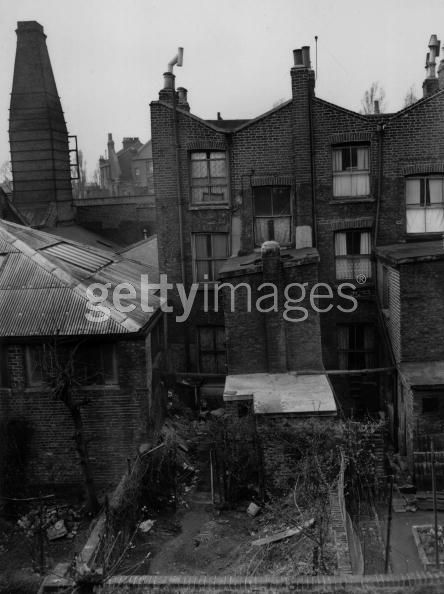
Assuming the long shot of 10 Rillington Place is of the actual location, the church to the right in the background, behind the wall, must have been demolished to make way for the Westway..
-
a_heathen_conceivably — 16 years ago(August 28, 2009 04:30 PM)
You mean the building behind the high brick wall at the end of the street adjacent to no 10, the end-terrace house? I thought it was a brickworks[?]. If it's the one I'm thinking of, then that's not a church spire, it's a factory chimney (for the kiln).
http://www.10-rillington-place.co.uk/html/period_pictures.html
"Oh look - a lovely spider! And it's eating a butterfly!"
''
,, -
Etherdave — 11 years ago(December 11, 2014 07:40 PM)
Here's a great photo of the 'church spire' from behind Rillington Place:
http://murderpedia.org/male.C/images/christie_john_reginald/0102.jpg
You can see the dilapidated back yard, the fence, and the washing-room. This photo creeps me out even more than shots of the front. -
culttv-2 — 3 years ago(March 15, 2023 08:00 AM)
The Westway is actually in the other direction, ie further to the north.
The church steeple you see in the background behind the factory is Notting Hill Methodist Church, and can be seen at 8:05 when the camera shot is zooming in on the 'To Let' sign in No.10's window.
Rillington Place was entered at St Marks Rd and ran approx 200 feet in an almost south-westerly direction, sandwiched between Lancaster Rd and the Metropolitan Railway, to a dead end at the wall next to the factory.
In the film at time 22:27 when Christie is walking to his house, and the kids are playing football in the street, that shot is looking almost northeast towards St Marks Rd and you can see the mechanic garage/petrol station, (with the triangular gable-ended roof) which is still there today. That gives you the exact location from that shot. The trees next to it are on the railway embankment. You can compare on Google Maps/Street View.
Bartle Road wasn't there yet, the houses to the left of the shot at 22:27 occupied that space where Bartle Road is now.
I wish I could post links but I don't have enough posts yet !